Re-inventing the Wilderness: Part 4 - Borders (+Trailblazing)
In this blog series, I will dissect the spatial elements of wilderness environments and explore how tabletop-friendly prep and mechanics could be leveraged to revise exploration procedures. If you’re looking to start from the beginning, you can find Part 1 here.
He looked at maps, and wondered what lay beyond their edges: maps made in the Shire showed mostly white spaces beyond its borders.
J.R.R. Tolkien, The Lord of the Rings (1954)
Borders demarcate two distinct regions, signifying a transition in gameplay much like the descent to a new dungeon level indicates a shift to a different environment, often accompanied by increased challenges. In play, these boundaries play a crucial role in shaping the dynamics and progression of the gaming experience.
Building borders
In a typical pre-modern world, borders often occur at topographic shifts; such as elevation (mountains, plateaus, valleys), bodies of water (rivers, lakes, shorefronts) or biome edges (wetlands, forest, wasteland). These aesthetic and mechanically relevant changes work well “in play” to make the transition between regions seen and felt in equal measure.
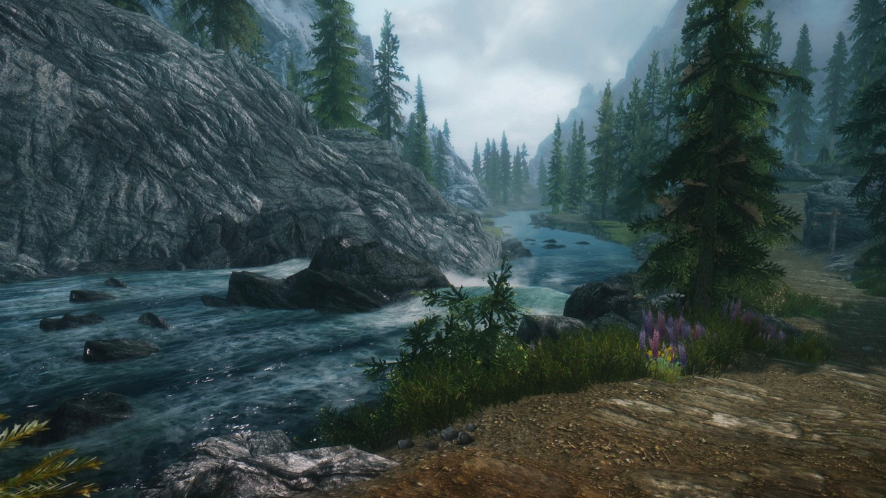 Rivers make great borders
Tip: Including paths along these topographic borders, such as a cliff edge or waterside route, also increases the permanence of the border and often adds engaging environmental features to any en-route combat encounters.
Barrier or seam?
Just as regions are valuable in separating the local politics and identity of different areas, the border is valuable in signaling a transition from one area to the other.
As such, there are two main types of borders:
- Isolating barrier - where passage is either impossible or incredibly cumbersome, so the regions are divided absolutely. A barrier border is great at isolating rival nations or dramatic shifts in theme (pastoral→nautical, temperate→desert, forest-whimsy→intrigue). Barriers have minimal accessible paths between the divided regions.
- Uniting seam - where either visual or mobility can penetrate the border, so the regions are tied together by an invisible boundary. A seam border works best if you want to relate the two regions, or if they share an allegiance or physical property. Seams have several accessible paths between the divided regions.
Note, that a region may have borders of differing properties. Perhaps a sea-front (barrier) in the west and a river valley (seam) in the east.
BONUS: Invisible walls Trailblazing
A small note… these trailblazing procedures don’t fit neatly in any post in this series but this one on Borders is the closest fit. Enjoy! ~SachaGoat
“There is a way that we may attempt,” said Gandalf. “I thought from the beginning, when first I considered this journey, that we should try it. But it is not a pleasant way, and I have not spoken of it to the Company before. Aragorn was against it, until the pass over the mountains had at least been tried.”
J.R.R. Tolkien, The Lord of the Rings (1954)
In this series, I have likened a few open-world design principles to those in video games. However, I want to make it clear that the presence of isolating barrier borders does not necessitate “invisible walls”.
Just as it’s possible (but cumbersome) to break through the walls/floors of a dungeon - you can trailblaze beyond the scope of designed paths or penetrate through geographic borders.
I recommend considering the following factors when refereeing trailblazing:
Altered procedure: I previously mentioned the use of special procedures to simulate risky paths. When trailblazing, these procedures are a great fit. Whereas travel down most paths is a montage with minimal interactivity, we “zoom in” when trailblazing. Players might identify routes up the cliff face, use cardinal directions and wind speed in the open ocean, or track resources in 10-minute Turns through an abandoned mine. I often collect and keep these mini-games to hand during play, if players surprise me with an off-path journey these procedures shine a spotlight on their progress.
Getting lost: When the trail-blazing procedure is complete (the clifftop is reached, the boat is docked, the mine exit is found…), there is a chance the players don’t know where they are. Look at the map and pick a local Point of Interest, describe any landmark signs that would indicate its presence (typically either a vertical element such as a tower, smokestack, etc, or a sensory theme* like a local smell, sound, or aesthetic). Armed with these options, players declare a direction to go and arrive at a Point of Interest if that direction is chosen.
//ASIDE: I have not tested it at the table, but I’d like to use red herring signs too - lures into the wild that make you more lost, such as eerie songs, strange lights, and whispers. If the players (intentionally or not) pick a direction with no canon Point of Interest, they fail to achieve significant progress toward recognisable landmarks, veering off onto an entirely alien trajectory. Refer to this fantastic post by Straits of Anián for inspiration and examples for “lost” Encounters and Points of Interest.//
Duration inconvenience: Regardless of any procedure risk, alternate routes are always more time-consuming than the traditional route. Total the canon travel duration and increase it by +1 (hour, watch, or day) - so a blazed trail in the direction of a POI 3 Watches away would take 4 Watches. A party can choose to commit time, wealth, and community effort to develop this into a new Path during their downtime. This decreases it to -1 (hour, watch or day) than the canon travel duration, finally creating a new shortcut.
*We’ll expand on landmarks in a later post but a small tidbit: Micro-landmarks can be an indication of the current region or nearby location (eg. the golden-leafed trees ahead are a reliable sign that the workshop of Althea the Gleamsmith is found ahead).
Trailblazing is initiated in 3 circumstances:
- Known location, unknown route. A clear landmark or instruction shows them where a location is but they have not uncovered the expected route. This forces them to make their own path over a border.
- Curiosity: Despite no information hooking them into the wilds, they venture out into the unknown in hopes of something. This is why I like the potential of dedicated encounters and locations for when you are lost - by refusing to follow the rules of exploration, you invite an otherworldly influence.
- Desperation. Due to enemy presence, inclement weather, or something else the party wishes to evade - they take an uncertain path. This is your “Mines of Moria moment”.
What’s to come…
In part 5 of this series, we’ll dive into Regions. The region is your backdrop for play and a major part of the setting’s identity. A single region hosts over 50 Points of Interest, a major town, conflicting factions, local resources, and unique encounters. Here’s a little preview of what’s involved in my current (utilitarian) region maps: 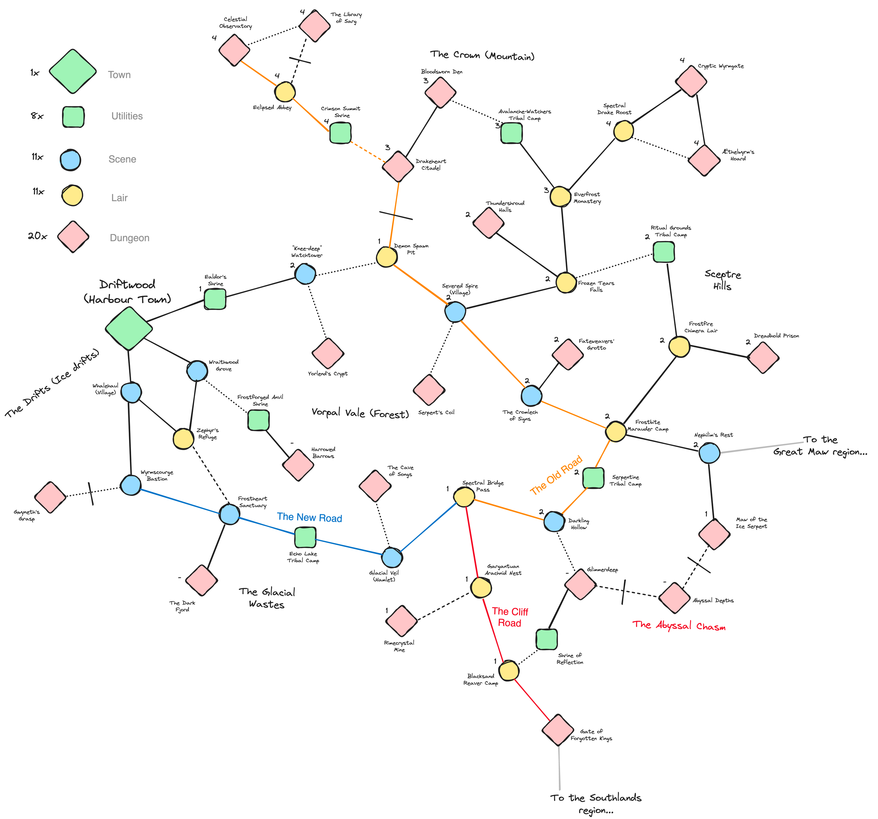
Further reading
https://bankuei.wordpress.com/2022/11/27/maps-for-play-2-the-ring-map-layout/
https://straitsofanian.blogspot.com/2023/01/how-to-be-erased.html
https://bankuei.wordpress.com/2023/05/20/down-the-road-local-situation-design/
https://wasitlikely.blogspot.com/2023/03/laws-of-land-meaningful-terrain-via-in.html
https://whosemeasure.blogspot.com/2023/02/another-method-for-meaningful-terrain.html
https://thealexandrian.net/wordpress/48383/roleplaying-games/hexcrawl-addendum-connecting-your-hexes
https://silverarmpress.com/the-wilderness-is-a-dungeon-jaquaysing-your-rpg-sandbox-setting/
https://headofthegoat.itch.io/lowlife
https://dicegoblin.blog/adventure-calendar-22-rules-for-climbing/