Re-inventing the Wilderness: Part 1 - Introduction
In this blog series, I will dissect the spatial elements of wilderness environments and explore how tabletop-friendly prep and mechanics could be leveraged to revise exploration procedures.
- Part 1 - Introduction
- Part 2 - Paths
- Part 3 - Points of Interest
- Part 4 - Borders (+Trailblazing)
- Part 5 - Regions
- Part 6 - Landmarks
- The final post, Part 7 is in-progress
This past year, my home-group have ventured across the much-anticipated Dolmenwood setting. In hexcrawling through this mystical land, I anticipated the classic dungeon-game sandbox experience… you know, hexes and such. Yet, in play we engaged most with Dolmenwood’s mesmerizing pathcrawl, where trails, rivers, and fairy roads intertwined with the classic hexmap terrain.
Dolmenwood. The best pathcrawl I’ve run?
But let me expand a little… Dolmenwood is (undeniably) a hexcrawl. But, whether it was a road, trail, river, shore, ley line, or fairy road - these many “paths” guided my players choices more than terrain and cardinal direction.
It took around 10 sessions, for my players to venture more than 1 hex away from a road. After a year of play, only 15% of explored hexes had no paths going through them.
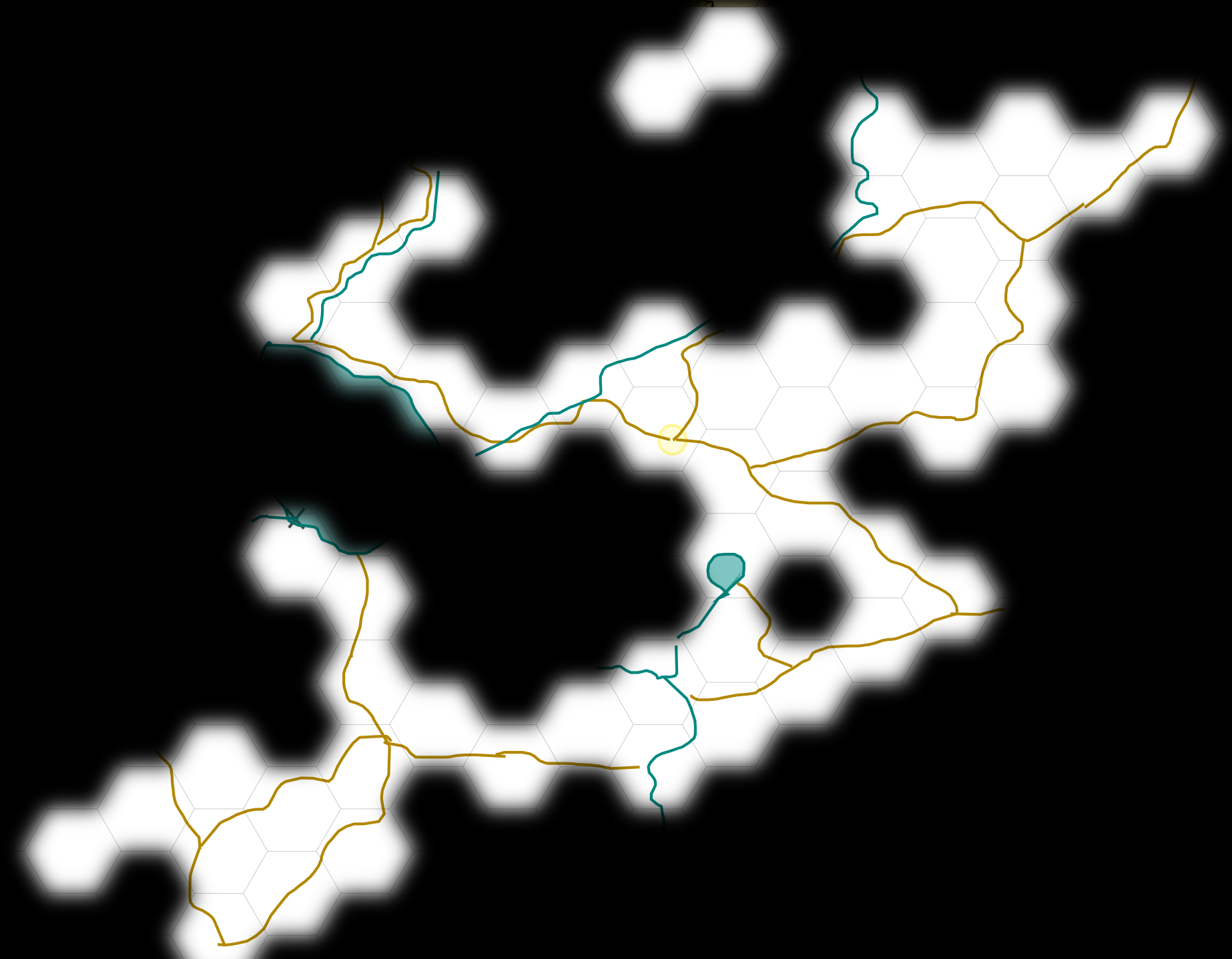 Dolmenwood GM map with terrain info and spoilers removed. Fog of war illustrates the explored hexes.
This revelation isn’t new but I wanted to share my experience after running Dolmenwood myself.
Players & paths
My players gave 3 reasons for their avoidance of unpathed regions:
- Safety. Though it was never player-facing, encounter table results were more civil near roads and getting lost wasn’t possible.
- Convenience. In our travel rules off-road travel in perilous terrain didn’t allow wagons and sometimes even horses.
- Confidence. When the destination was clear via rumour or signposts, they trusted their route. When it was unclear, it became a hook for exploration.
When they did go off-road (either for a shortcut or pursuing a rumour in the wilds), their familiarity with those hexes formed new “trails” that they’d frequent on return journeys (eg. “Let’s return to Prigwort via Fog Lake. We can check if anything new has moved into the cave as we pass it”).
Unlike the fairly pathless Outdoor Survival map, Dolmenwood is riddled with routes and trails that lead to or orbit its focal points. It’s exceedingly well-designed but left me frustrated because the hexcrawl procedures were focused on off-road exploration.
To summarise (before I get to the “re-invention” my post title imperiously uses):
- When hexes are not player-facing, paths are more easily understood and communicated than the multi-directional choices of a hex
- Unknown routes (eg. following environmental patterns, unlabelled paths or otherworldly portals) are enticing disruptions to default paths
- Locations along paths are more likely to be engaged with (and encountered several times)
- Even when venturing off-road, players formed new “paths” through an understanding of hex content
- As humans, we mostly navigate by route and even when orienteering through the wilderness we create routes ourselves.
Farewell Outdoor Survival!
Now there’s this interesting paradox I’ve noticed in the OSR space. Despite the popularity of wilderness products, there is a lot of guidance on randomly generating wilderness (not just encounters).
Whilst dungeon design is filled with tight advice, checklists, and theory… wilderness design is either procedures that prioritize geological realism or scalable randomisation.
So, I wanted to experiment with what open-world design would look like in my games without the baggage of the Outdoor Survival-derived hexcrawling. My hope isn’t that this replaces the classic hexcrawl gameplay that I still love - but that it prompts us to think of more immersive and gameable procedures for wilderness exploration.
The Image of the Wilds
After a five-year study, urban theorist Kevin Lynch reported how observers formed mental maps of their surroundings in his book, The Image of the City (1960). In it he detailed five basic elements that comprise our geographic mapping: Paths, Landmarks, Districts, Edges, and Nodes. These terms have been used by video game world designers (Stop Getting Lost: Make Cognitive Maps, Not Levels by Nicolas Oueijan) and I’ve found they work excellently in evolving the TTRPG sandbox experience.
Repurposing the urban definitions for the rural framework of most dungeon-fantasy sandboxes, we have the following:
- Paths: These are the channels along which one customarily, occasionally or potentially moves. They may be roads, trails, rivers, coasts etc. For most, these are the predominant elements in their cognitive image. People observe the world while moving through it, and it is along paths that other environmental elements are understood, arranged and related.
- Points: (formerly Nodes) Points of interest (POIs) or nodes are the strategic spots which one can enter, and which are the intensive foci to and from which they are traveling. They may be primarily junctions, places of a break in transportation, a cross-road or convergence of paths. Or they may be concentrations, which gain their importance from being the condensation of some use or physical character, as a ruin, mine, trading post etc. Some of these are “cores”, the focus and epitome of a region, over which their influence radiates and of which they stand as a symbol.
- Borders: (formerly Edges) These are the linear elements not used or considered as paths by the observer. They are boundaries between two phases, linear breaks in continuity: cliffs, overgrown trails, territory edges etc. They are lateral references rather than coordinate axes. Such edges may be barriers, more or less penetrable, which close one region off from another; or they may be seams, lines along which two regions are related and joined together.
- Regions: (formerly Districts) These are the sections of the world that one mentally enters “inside of”, and which are recognisable as having some common, identifying character. Always identifiable from the inside, they are also used for exterior reference if visible from the outside.
- Landmarks: These are another type of point-reference, but in this case, one does not enter within them, they are external. They are usually a rather simply defined physical object. Some are distant, typically seen from many angles and distances, and used as radial references: tower, statue, or mountain. They may even be extremely distant, symbolising constant direction (like our sun and stars). And some are extremely local (restricted to specific localities and approaches), the innumerable natural and man-made details that are clues to the identity of a place; these are the wilderness equivalent of dungeon-dressing.
What’s to come…
Each part of this series will dive into each of those components, going into detail about how I use this framework to both prep and run engaging pathcrawls. Read part 2 “Paths” now!
Further Reading
https://permacrandam.blogspot.com/2022/09/hexcrawls-are-pathcrawls.html
https://playfulvoid.game.blog/2022/06/29/wilderness-walls-and-halls-streamlining-hexcrawls/
https://silverarmpress.com/why-i-use-point-crawls-more-than-hex-crawls/
http://detectmagic.blogspot.com/2014/04/pathcrawl.html
https://traversefantasy.blogspot.com/2023/05/od-and-outdoor-survival.html
https://jacobmarkshasablognow.blot.im (Jacob promised to blog about the making of his new point crawl, Exalted Order of the Mystic Moose. Watch this space.)
Finally, I highly encourage anyone who values this series to watch the GDC talk by Nicolas Oueijan from thatgamecompany: