BLOGGIES 2024 Concludes!
The Bloggies 2024 have come to a close, and what an incredible celebration of TTRPG blogging it has been! A phenomenal range of talent, creativity, and passion across all categories.
Over the past few weeks, readers voted for their favorite posts in Theory, Gameable, Advice, and Review categories, as well as in our new bonus category - Debut Blog. And after a thrilling final showdown, we have crowned an overall winner.
But first, I want to take a moment to recognize the winners across each category:
Theory Category
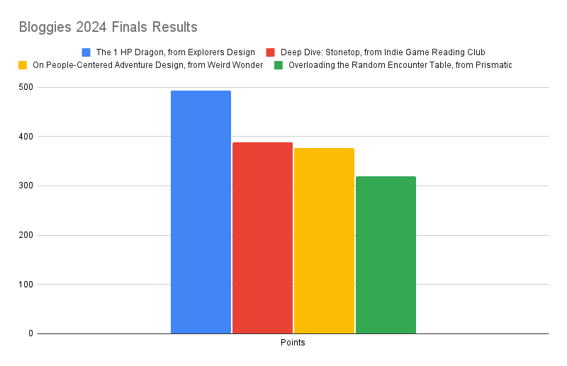
🥇 Gold: The 1 HP Dragon, from Explorers Design
🥈 Silver: In Praise of Legwork, from Sam Sorensen
🥉 Copper: Interesting Social Situations, or The Discourse Post, from Rise Up Comus
Gameable Category
🥇 Gold: Overloading the Random Encounter Table, from Prismatic Wasteland
🥈 Silver: The Bell Curving Encounter Table, from Pointless Monument
🥉 Copper: A Person Shaped Hole, from Mindstorm Press
Debut Blog (bonus category)
🥇 Gold: MURKMAIL
🥈 Silver: WOBBLEROCKET
🥉 Copper: Among Cats and Books
Advice Category
🥇 Gold: On People-Centered Adventure Design, from Weird Wonder
🥈 Silver: Setting up an OSR Sandbox, from Roll to Doubt
🥉 Copper: Monster Checklist, from Goblin Punch
Review Category
🥇 Gold: Deep Dive: Stonetop, from Indie Game Reading Club
🥈 Silver: The loss we gain from a Thousand Year Old Campfire, from Hendrik ten Napel
🥉 Copper: The Sci-Fi Special Edition, from The Soloist
Platinum Medalist: The Best of the Best!
For the final showdown, the four gold medalists from the main categories faced off in a ranked vote over the last 48 hours. And I’m please to announce the winner is…
🏆The 1 HP Dragon🏆, from Explorers Design
Congratulations to Clayton for winning the top honour this year!
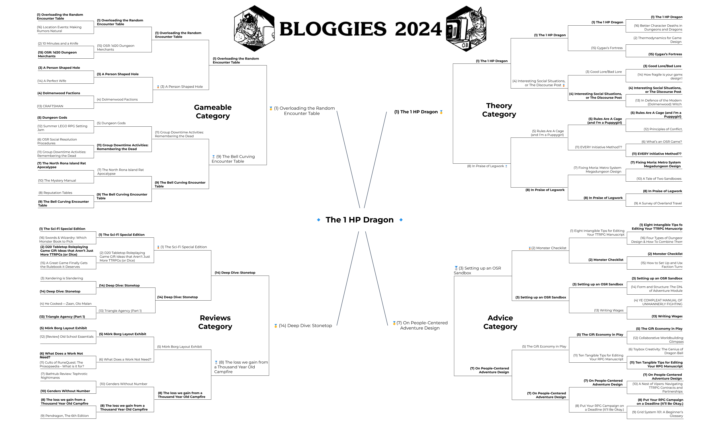 Tournament brackets of the main categories
Winner Speeches
Below, we have words from our gold medalists across the main categories:
Clayton (Explorer’s Design), author of The 1 HP Dragon - 2024 Winner of Best of the Best, and Best Theory Post
Like many of the writers featured in the Bloggies this year, I wrote The 1 HP Dragon to excise it from my mind. This HP-free, damage-free, monsters-as-puzzles riddle has been in my head for years. I had no idea others would find it interesting enough to like, share, or vote for. It turns out, despite all the systems out there, a lot of us are still trying to slay the same dragon. So, thank you for reading it and bestowing it a gold in the theory category. The renewed interest in my ramshackle experiment has given me motivation to keep writing — which is maybe the best reward for blogging.
WF Smith (Prismatic Wasteland), author of Overloading the Random Encounter Table - 2024 Winner of Best Gameable Post:
I want to thank everyone who voted for my blog post, everyone who read my post, and the people who engaged with my post in any way, like stealing it for your own design or writing your own post iterating on it. I am proud of the post but frankly I am a father to all my blog posts and love them all equally. I think they should all get medals. If you loved this post, you should go read my whole backlog. Clear your calendar for tomorrow; it’ll be worth it.
Since I get the microphone for a moment, my message to all those listening is: start a blog if you don’t have one already and if you do have a blog, go post. Go write a post right now. It doesn’t have to be good, it just has to be yours.
Amanda (Weird Wonder), author of On People-Centered Adventure Design - 2024 Winner of Best Advice Post:
Winning this was a complete surprise as I was just speaking to what I am personally passionate about when it comes to adventure design and writing. I think we can make adventures rich with interesting people in dire situations. Thank you everyone who voted for me!
Paul (Indie Game Reading Club), author of Deep Dive: Stonetop - 2024 Winner of Best Review Post:
Reviews — critique, really — is the thing everyone says they want more of but nobody wants to support. Tough gig. Lonely. You don’t make a lot of friends doing it until you give their favorite thing a glowing report.
I’ve been a proponent of play-informed personal critique for 20 years. There’s just no way to really understand what a game is doing without seeing it in action. You have to feel it sloshing around in your own mind, watch other folks work with it, read and re-read and take notes and just sit and ponder. Where do the rules stop and my experience starts? How much lifting am I doing? Is the game fun, or smart, or inspiring on its own merits?
Critique exists in a three way conversation with creators and players. It’s gratifying to hear someone engaging with your work seriously, but growing from that engagement is what separates the pros from the wannabes. So a note to the creators out there: engage with the critic’s work as seriously as we engaged with yours. Share it, for good or ill. This is the only way the conversation can continue.
I hope more folks will consider getting into the critique game! The only way to start is to start. Be humble. Learn things. Consume everything you can get your hands on. Sit with it, chew on it, feel out how you engage with the work personally and not just write a thumbs up/down to eager buyers. It’s not your job to market for the creators. It is your job to take it seriously.
What’s next?
I just want to echo a lot of these winner speeches above and say a massive thank you to everyone who participated in this year’s Bloggies… whether by writing, reading, voting, sharing etc. There was a huge amount of engagement (even after a year that scattered a lot of online ttrpg communities).
Not to take away from our brilliant medalists but plenty of my favourite posts this year aren’t mentioned in this post. If you missed the voting rounds and want to read more than a handful posts, please go back to the original finalists and read away. You won’t regret it.
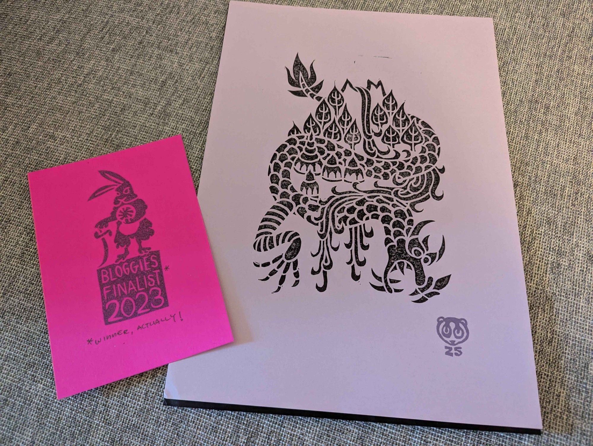
Zedeck’s schedule unfortunately meant that he couldn’t start the lino print prizes sooner. However, I can confirm that every Gold category winner will be getting a print. Huge thanks for Zedeck for his generous contribution here - the design looks epic!
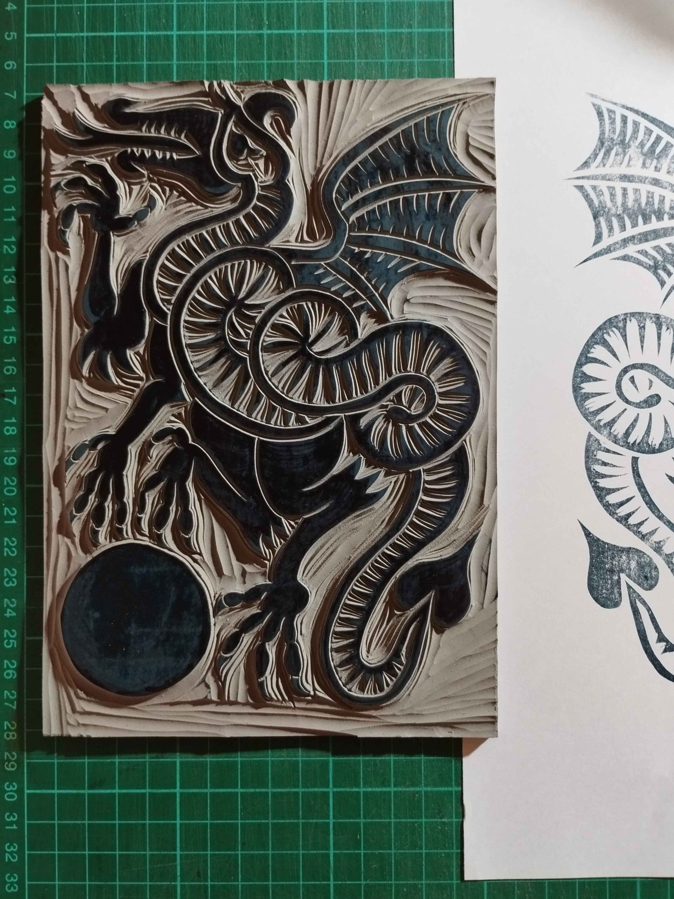 Zedeck Siew’s official 2024 Bloggies lino cut (work-in-progress)
And finally, it is tradition for the Bloggies platinum medalist (best of the best winner) to take over as custodian of the competition for the following year - so it will be up to Clayton what happens next year? Will he host? Set up a judges board? Will he reinvent the procedures? Alter the categories? Rename it? Run it all on one day? Burn the whole damn thing down…? We shall see.
As for me, it has been an honour to host such a brilliant year for blogging. Thanks for all your patience and support.
Blogs are ours.
BLOGGIES 2024 Commence!
Want to skip to the finalists? Click here
The Bloggies 2024 has concluded. Read about our winners here
🥇🥈🥉 EDIT: Theory Medalist Announcement
🥇🥈🥉 EDIT 2: Gameable Medalist Announcement
🥇🥈🥉 EDIT 3: Debut Blog Medalist Announcement
🥇🥈🥉 EDIT 4: Advice Blog Medalist Announcement
🥇🥈🥉 EDIT 5: Reviews Blog Medalist Announcement
What are the Bloggies?
 Official BLOGGIES 2024 art ‘Blugtarp Blogeye and Weyman the Well-Read’ by Hodag (@HODAGRPG)
The BLOGGIES are a yearly awards event that debuted on the Prismatic Wasteland blog in 2022 to celebrates standout TTRPG blog posts from the past year — shining a light on the posts that linger in your mind long after you’ve closed the tab. The awards are a way to recognize the creativity and hard work that keeps the TTRPG blogging scene thriving.
I won Best Blog Post, last year. So Zedeck Siew passed the sceptre to me for hosting 2024.
Why does TTRPG blogging matter?
The TTRPG space has always thrived on the exchange of ideas, a collaborative culture woven into its very fabric. Its roots trace back to the mimeographed pages of wargaming and fantasy zines of the 1970s, where enthusiasts debated mechanics, shared house rules, and dreamed up entire worlds. These grassroots publications were the lifeblood of the early hobby, connecting far-flung players in a time before the internet. As the decades rolled on, the scene migrated to message boards and forums, where ideas sparked across threads and communities blossomed in the glow of dial-up modems. Today, blogging bears this torch, becoming the primary venue for deep dives into mechanics, nuanced critiques of games, and the sharing of gameable treasures.
Blogs offer a slower, more reflective pace compared to the quick hits of social media, with space to explore ideas in depth and return to them long after they’re posted. They keep alive the spirit of experimentation and sharing that shaped the hobby in its earliest days, providing a platform for creators to speak directly to players and for players to contribute back to the larger conversation. It’s a lineage of creativity and collaboration, continuing to evolve while staying true to its roots.
Who are the finalists?
Throughout December, the community has nominated over 320 unique blog posts for this year’s BLOGGIES (over double the previous year!).
I have spent the last few days reading (or re-reading) the entries to narrow down 16 finalists per main award category below (64 total). Special attention was given to posts with multiple nominations or unique form and perspective and deliberate care was taken to avoid including multiple entries by the same author within a single category. Then, each category bracket was seeded in order of number of nominations received.
Finalists will go head-to-head in a public poll, see details here.
Theory Finalists
This category highlights the ideas, criticism, or analysis about TTRPG culture, aesthetic, politic, and history.
(1) The 1 HP Dragon, from Explorers Design
Brings the ‘16 HP Dragon’ to it’s dramatic, theoretical conclusion.
vs
(16) Better Character Deaths in Dungeons and Dragons, from Wobble Rocket
Gives thoughtful examples of character deaths and how to improve our player character’s end.
(2) Thermodynamics for Game Design, from Benign Brown Beast
An engineer’s exploration of character attributes and how to simplify their management.
vs
(15) Gygax’s Fortress, from All Dead Generations
Examines early Gygaxian adventure design divergence from modern design trends.
(3) Good Lore/Bad Lore, from Mazirian’s Garden
Frames issues with lore bloat in TTRPGs and offers practical solutions for actionable lore.
vs
(14) How fragile is your game design?, from Skeleton Code Machine
Analyzes “fragility” in game design, offering examples, insights, and practical tips for designers.
(4) Interesting Social Situations, or The Discourse Post, from Rise Up Comus
Practical advice for social NPC interactions without the bloat of an over-engineered subsystem.
vs
(13) In Defence of the Modern (Dolmenwood) Witch, from Kobolds & Konsequences
Explores Dolmenwood’s portrayal of women and the occult from a female perspective.
(5) Rules Are A Cage (and I’m a Puppygirl), from Jay Dragon
Visionary articulation of a unifying game idea that bridges diverse play cultures.
vs
(12) Principles of Conflict, from Dododecahedron
Presents principles for referees handling conflict and outlines a conflict resolution system.
(6) What’s an OSR Game?, from Playful Void
An excellent overview of the current state of the OSR movement.
vs
(11) EVERY Initiative Method??, from Knight at the Opera
A deep-dive comparative analysis of initiative systems across all TTRPGs.
(7) Fixing Moria: Metro System Megadungeon Design, from Silverarm
Practical advice for rethinking overdone megadungeons (and cities) in OSR products.
vs
(10) A Tale of Two Sandboxes, from Mythic Mountain Musings
A landmark post articulating the Classical Adventure Gaming (CAG) style.
(8) In Praise of Legwork, from Sam Sorensen
Introduces the concept of “legwork” to describe RPG book utility to GMs.
vs
(9) A Survey of Overland Travel, from Beau Rancourt
Comprehensive analysis of wilderness travel and logistics in various OSR games.
Gameable Finalists
These posts provide ready-to-use content like monsters, subsystems, or scenarios that can be directly added to your game.
(1) Overloading the Random Encounter Table, from Prismatic Wasteland
Encounter procedures nested into a universal 3d6 roll, with a play-ready example.
vs
(16) Location Events: Making Rumors Natural, from Behind the Helm
Gives examples for dynamic rumors that disrupt the static traditional format.
(2) 10 Minutes and a Knife, from Benign Brown Beast
A MOSAIC-strict subsystem for hunting and butchery, adaptable to any game.
vs
(15) OSR: 1d20 Dungeon Merchants, from Coins and Scrolls
Twenty evocative dungeon merchants ready to drop into your dungeon game.
(3) A Person Shaped Hole, from Mindstorm Press
A fun and collaborative hook to tie all the characters together at the start of a new game.
vs
(14) A Perfect Wife, from Slow Loris Press
An exceptional Pontianak-themed urban horror investigative adventure module available for free.
(4) Dolmenwood Factions, from Among Cats and Books
In-depth breakdown of Dolmenwood factions with new NPCs and systems for faction management.
vs
(13) CRAFTSMAN, from Spiceomancy
An ARG disguised as a GLoG class… or a GloG class disguised as an ARG?
(5) Dungeon Gods, from Dungeon Doll
Introduces petty gods, shrines, and a prayer/boon system to drop into your next dungeon game.
vs
(12) Summer LEGO RPG Setting Jam, from DIY and Dragons
A community-driven RPG jam that brings together creators to collaborate via blogs (no central platform needed).
(6) OSR Social Resolution Procedures, from Occultronics
Expands on Morale and Reaction rolls to create guidelines for evaluating persuasive actions based on player method.
vs
(11) Group Downtime Activities: Remembering the Dead, from Mazirian’s Garden
A thoughtful downtime subsystem for acknowledging and memorialising fallen player characters.
(7) The North Rona Island Rat Apocalypse, from Molten Sulfur
A real-world history, geography, and ecology presented as gameable material.
vs
(10) The Mystery Manual, from Strange Aeons
A collection of free open-ended OSR mystery adventures set in a Call of Cthulhu-inspired world.
(8) Reputation Tables, from Luke Gearing
A simple reputation subsystem that parallels player-character progression.
vs
(9) The Bell Curving Encounter Table, from Pointless Monument
Uses bell-curves to nest civilization, borderlands and wilderness encounters into a unified table.
Advice Finalists
This award acknowledges the tips and methods about play, prep or publishing within the scene.
(1) Eight Intangible Tips for Editing Your TTRPG Manuscript, from Playful Void
Explores a neglected aspect of indie design with experienced insights.
vs
(16) Four Types of Dungeon Design & How To Combine Them, from Dice Goblin
A concise summary of four effective dungeon design approaches with practical examples.
(2) Monster Checklist, from Goblin Punch
Codifies decades of old-school monster design into a fresh and approachable format.
vs
(15) How to Set Up and Use Faction Turns, from Among Cats and Books (Elmcat)
In-depth post on hacking the Mausritter downtime system for faction turns.
(3) Setting up an OSR Sandbox, from Roll to Doubt
A digestible masterclass in creating a sandbox for immediate play.
vs
(14) Form and Structure: The DNA of Adventure Modules, from Loot the Room
Fascinating comparison of adventure module structures across systems.
(4) YE COMPLEAT MANUAL OF UNMANNERLY FIGHTING, from Press the Beast
A rare gem offering actionable advice for players, especially fighters.
vs
(13) Writing Wages, from Luke Gearing
Insightful behind-the-scenes post on creative processes and sustainable writing practices.
(5) The Gift Economy in Play, from Archon’s Court
Explores the mechanics of gift economies and how to use them effectively in play.
vs
(12) Collaborative Worldbuilding: Glimpses, from Mindstorm Press
A useful technique for collaborative worldbuilding that maintains creative consistency.
(6) Toybox Creativity: The Genius of Dragon Ball, from Prismatic Wasteland
An inspiring deep-dive into creativity and fantasy, cutting through design debates.
vs
(11) Ten Tangible Tips for Editing Your RPG Manuscript, from Sam Sorensen
Succinct, actionable advice for editing RPG manuscripts.
(7) On People-Centered Adventure Design, from Weird Wonder
Fantastic guide to placing people (and their problems) at the core of your next adventure.
vs
(10) A Nest of Vipers: Navigating TTRPG Contracts and Partnerships, from Uncanny Spheres
In-depth analysis and commentary on the commercial and contractual risks of TTRPG publishing.
(8) Put Your RPG Campaign on a Deadline (It’ll Be Okay.), from Silver Arm
Persuasive argument for scoping campaign length to ensure satisfying conclusions.
vs
(9) Grid System 101: A Beginner’s Glossary, from Explorers Design
A generous, beginner-friendly resource on layout design for TTRPG books.
Review Finalists
An award for the reviews of TTRPG-adjacent books, games, systems, content, adventures, or products.
(1) Mothership: Engine Malfunction, from Knight at the Opera
Comprehensive and provocative review of a successful indie darling.
UPDATE 13/01/2025: Upon their request, Dwiz’s post has been withdrawn from the Bloggies. A new finalist post will be placed in this bracket before the Review vote starts on January 24th. Bracket seeding will otherwise not be updated.
UPDATE 24/01/2025: This post has been replaced with another that narrowly missed the initial finalist list.
(1) The Sci-Fi Special Edition, from The Soloist
A special feature covering solo and GM-less sci-fi RPGs.
vs
(16) Swords & Wizardry: Which Monster Book to Pick, from Attronarch
In-depth analysis of the various S&W bestiaries, complete with an index of 1,682 monsters.
(2) D20 Tabletop Roleplaying Game Gift Ideas that Aren’t Just More TTRPGs (or Dice), from Prismatic Wasteland
Answers the call for better gift guides, blending practical suggestions with GMing advice.
vs
(15) A Great Game Finally Gets the Rulebook it Deserves, from The Weeping Stag
Celebration and thoughtful analysis of the new Star Trek Adventures edition.
(3) Xandering is Slandering, from DIY & Dragons
Thorough critique of the re-coining of the design technique, “Jaquaysing”.
vs
(14) Deep Dive: Stonetop, from Indie Game Reading Club
Mechanical deep-dive into the long-anticipated Stonetop PbtA game.
(4) He Cooked — Zaan, Olo Malan, from False Machine
A fascinating review, nudging Hugh Cook onto my unofficial Appendix N reading list.
vs
(13) Triangle Agency (Part 1), from Split Party
A post-play discussion about the emergent mechanics of Triangle Agency.
(5) Mörk Borg Layout Exhibit, from Explorer’s Design
Fresh take on Mörk Borg’s iconic layout, highlighting its unique aesthetic strengths.
vs
(12) [Review] Old School Essentials, from Beau Rancourt
Meticulous, data-driven review of one of the OSR’s defining retroclones.
(6) What Does a Work Not Need?, from Sam Sorensen
A review of Luke Gearing’s The Isle grapples with the very question of what an adventure is/should be.
vs
(11) Cults of RuneQuest: The Prosopaedia - What is it for?, from El Rune
A review of Glorantha’s system-neutral deity catalog and it’s value beyond RuneQuest.
(7) Bathtub Review: Tephrotic Nightmares, from Playful Void
From this consistent series, comes an honest critique of Mörk Borg’s latest outing.
vs
(10) Genders Without Number, from Traverse Fantasy
A review that goes beyond the surface, and digs deeper into the game’s themes and politics.
(8) The loss we gain from a Thousand Year Old Campfire, from Hendrik ten Napel
Concise, heartfelt review of a truly unique game from Tim Hutchings.
vs
(9) Pendragon, The 6th Edition, from Andrew Logan Montgomery
A loving tribute to Greg Stafford’s magnum opus in its ultimate form.
Bonus Round: Debut Blog
An initiative to spotlight new bloggers who stood out in their debut year. This category will have one big vote, therefore they are not seeded in tournament brackets.
Where’s the ‘Blog Series’ category?
Award for a series of posts from the same blog.
I had originally planned to a bonus round for ‘Blog Series’ (series of posts from the same blog). However, after reviewing the nominations it’s become clear that posts within a larger series don’t struggle to stand out (the majority of them were already finalists in a main category above). As a result, I have made the decision to cut the ‘Blog Series’ bonus category. However, fear not! All nominations for this category were considered amongst the other nominations.
What’s next?
With the nominations now narrowed down to the above finalists, as with previous years, we now turn to public voting. Knock-out bouts (ie, a tournament) will be run throughout January. The Debut Blog bonus category will be a straight bohort (ie, a single round of voting), partway through the month.
THEORY
- 3 January (Friday): Round of 16 - Results
- 4 January (Saturday): Round of 8 - Results
- 5 January (Sunday): Round of 4 - Results
- 6 January (Monday): Quarter-finals (winner of category) - Results
GAMEABLE
- 10 January (Friday): Round of 16 - Results
- 11 January (Saturday): Round of 8 - Results
- 12 January (Sunday): Round of 4 - Results
- 13 January (Monday): Quarter-finals (winner of category) - Results
Bonus Category: DEBUT BLOG
ADVICE
- 20 January (Monday): Round of 16 - Results
- 21 January (Tuesday): Round of 8 - Results
- 22 January (Wednesday): Round of 4 - Results
- 23 January (Thursday): Quarter-finals (winner of category) - Results
REVIEW
- 24 January (Friday): Round of 16 - Results
- 25 January (Saturday): Round of 8 - Results
- 26 January (Sunday): Round of 4 - Results
- 27 January (Monday): Quarter-finals (winner of category) - Results
BEST BLOG POST OF 2024
- 31 January (Friday): Finals (winner of 2024 BLOGGIES) - Results
What’s the prize?
When Zedeck hosted last year, he created some awesome appropriately themed lino art for the category winners. I am please to say he’s agreed to do so again.
 Lino-art prize for my 2023 post. Art by Zedeck Siew)
The BLOGGIES 2024: Call for Nominations!
The BLOGGIES are back, and it’s time to celebrate the best of the TTRPG blogging community!
Who are you?
Hey! I’m Sacha (or SachaGoat). I am not a TTRPG creator, journalist or even prolific blogger (seriously, this is my 7th post). However, it’s become a tradition for this grass-roots award to be hosted by the previous year’s winner, hence why Zedeck Siew passed the sceptre to me for 2024.
What are the Bloggies?
Official BLOGGIES 2024 art by Hodag (@HODAGRPG)
The BLOGGIES are a yearly awards event that debuted on the Prismatic Wasteland blog in 2022 to celebrates standout TTRPG blog posts from the past year — shining a light on the posts that linger in your mind long after you’ve closed the tab. The awards are a way to recognize the creativity and hard work that keeps the TTRPG blogging scene thriving.
How do I nominate a great blog post?
You can submit eligible posts for nomination via this Google Form.
As with last year, there are four main Award Categories:
- Theory — Explores broad ideas, criticism, or analysis about TTRPGs, including their cultures, aesthetics, politics, and history.
- Gameable — Provides ready-to-use content like monsters, subsystems, or designs that can be directly added to your games.
- Advice — Shares ideas, tips, or methods for improving gameplay, enhancing player experience, or refining play culture.
- Review — Evaluates specific TTRPG books, games, systems, adventures, or products.
This year, I am introducing two Bonus Categories. You can be nominated into these, in addition to one of the above main categories:
- Debut Blog — Award for a blog whose first post debuted in 2024.
- Blog Series — Award for a series of posts from the same blog that garners multiple nominations this year.
The nomination deadline is Midnight GMT, 31 December 2024.
What is “an eligible post”?
Eligible posts are:
- Published between December 1 2023 and November 30 2024.
- Hosted on a personal website, or blogging platform (eg. blot.im, blogspot, ghost, medium, patreon, substack). Social media threads will not be considered.
- Must be classifiable into the TTRPG post categories (theory, gameable, advice, review).
- Accessible without a login, membership or subscription.
You can nominate multiple posts but avoid nominating a post you have already nominated.
How does a post win?
In early 2025, I will review and group the nominations. Like last year, the main Award Categories will have knock-out bouts (ie, a tournament) with public voting. The new Bonus Categories will be a straight popular vote (ie, only 1 round per category).
Why does TTRPG blogging matter?
The TTRPG space has always thrived on the exchange of ideas, a collaborative culture woven into its very fabric. Its roots trace back to the mimeographed pages of wargaming and fantasy zines of the 1970s, where enthusiasts debated mechanics, shared house rules, and dreamed up entire worlds. These grassroots publications were the lifeblood of the early hobby, connecting far-flung players in a time before the internet. As the decades rolled on, the scene migrated to message boards and forums, where ideas sparked across threads and communities blossomed in the glow of dial-up modems. Today, blogging bears this torch, becoming the primary venue for deep dives into mechanics, nuanced critiques of games, and the sharing of gameable treasures.
Blogs offer a slower, more reflective pace compared to the quick hits of social media, with space to explore ideas in depth and return to them long after they’re posted. They keep alive the spirit of experimentation and sharing that shaped the hobby in its earliest days, providing a platform for creators to speak directly to players and for players to contribute back to the larger conversation. It’s a lineage of creativity and collaboration, continuing to evolve while staying true to its roots.
If you write blog posts, share blog posts, or just read them - thank you for supporting the vibrant TTRPG blogging community. Let’s make the 2024 BLOGGIES the best yet!
Re-inventing the Wilderness: Part 6 - Landmarks
In this blog series, I will dissect the spatial elements of wilderness environments and explore how tabletop-friendly prep and mechanics could be leveraged to revise exploration procedures. If you’re looking to start from the beginning, you can find Part 1 here.
“But I don’t even know the way back to my own country,” pleaded Edmund.
“That’s easy,” answered the Queen. “Do you see that lamp?” She pointed with her wand and Edmund turned and saw the same lamp-post under which Lucy had met the Faun. “Straight on, beyond that, is the way to the World of Men. And now look the other way”—here she pointed in the opposite direction—“and tell me if you can see two little hills rising above the trees.”
“I think I can,” said Edmund.
“Well my house is between those two hills. So next time you come you have only to find the lamp-post and look for those two hills and walk through the wood till you reach my house. You had better keep the river on your right when you get to it.”
C. S. Lewis, The Lion, the Witch and the Wardrobe (1950)
We use visual information all the time in dungeons; the yawning entrance, the shifts in aesthetic as you delve deeper, clues to a puzzle, or even the hints of a deadly trap. In fact, it’s become common game-advice to present as much information as possible, to foster engaging decisions in play. And we see the word ‘Landmark’ crop up in the popular Landmark/Hidden/Secret refrain, but for overland wilderness travel it takes even more forms.
Landmarks are the reference points we rely on in the world above to convey visual information. They tell us where we are, can help us navigate and can share valuable context (or even elicit a specific emotion). They are typically found at three scales:
- Micro: Small, localized (e.g. tree stump, skeleton).
- Meso: Medium-sized, unique within their area (e.g. small house, witch’s hut).
- Macro: Large, visible from great distances (e.g. massive tower, the North star).
Micro Landmarks
When navigating through repetitive environments, you can use micro landmarks to disrupt the locale’s pattern and highlight important points or paths.
This type is most often used to highlight the start of a natural path. Without these micro landmarks, only man-made paths such as roads and trails are simple to navigate in the shared game fiction.
You find a posed skeleton pointing north-west, or your sentient torchlight flickering in a cardinal direction against the wind, or you hear the hum of a magic ley-line.
The other use is flavour; I’m not talking about fanciful fluff here, but genuine gameable information about the space you’re moving through. This may be a shift in foliage hue, terrain texture, sound, smell etc. Instead of marking the start of a path, it’s used to acknowledge the adjacent Points of Interest and signify local changes along a path.
Following the coast south from the village, the fishing boats start disappearing from the horizon, the sand gives away to pebbles, then stones that require you to clamber over, before long you’re hopping over rock-pools as cliffs rise to your left, the water here has an odd ruddy colour - you’re nearly at Bloodsong Grotto.
None of these details are POIs in themselves, but this flavour allows players to navigate both by prior instruction (eg. an NPC says to follow the coast until it’s rocky and they find a red-water cove) or prior visit (eg. they want to find their way back here). Personally, I use this as an at-the-table technique, rather than a part of prep. Simply, consider how the environment changes in the transition between the POI you’re departing and the one you are approaching.
For micro landmarks especially, uniqueness is paramount. It is only by actually disrupting the normal environment do these details actually become micro landmarks; especially because of their smaller, subtler scale. If they aren’t unique, players won’t pay much attention.
Meso Landmarks
Whilst micro landmarks are all about paths, meso landmarks are tied to Points of Interest (POIs). As previously discussed, we typically only use dead-end paths when leading to dungeons. So, before they explore a Point of Interest, players need to actively make a decision to engage with it, as opposed to simply moving along their chain of paths to the next site.
Meso landmarks are effectively “landmark information” (in the landmark/hidden/secret sense) about a Point of Interest. What can we see as we approach or pass it?
South of the road, you see yellow-streamers fly from a collection of huts at the cliff’s base. A great fire burns stubbornly infront of a huge stone tree, casting a twisting shadow up the cliffside.
At the dungeon-scale, we’re dealing primarily with meso landmarks, so these are not really new or unique. The key takeaway here is to communicate what the POI is (a community, a monster lair, faction fort, or something weird) from a distance. The information presented here will decide whether players investigate, take a note and move on, or straight-up ignore your locations.
Macro Landmarks
Walt Disney’s Imagineering team popularised the term “Weenie” to refer to a prominent, visually striking landmark that serve as focal point to draw players (or visitors of theme parks) towards them, and help them orient around it. It has been adopted in video game design, and in abstracted tabletop exploration it takes the form of the ‘macro landmark’.
These landmarks are tall, striking and unique. Often they are omnipresent, visible across the entire region (or area). That may seem excessive to you, even in a fantasy world - so how about some real-world examples:
| Landmark | Visibility Range (miles) | Visibility Range (per 6 mile hex) |
|---|---|---|
| Mount Fuji | 62 | 10 |
| Burj Khalifa | 59 | 9 |
| Willis Tower | 40 | 6 |
| Eiffel Tower | 43 | 7 |
| CN Tower | 37 | 6 |
| Empire State Building | 30 | 5 |
Most of these examples are man-made because that often guarantees a unique silhouette; but in your fantasy world you can conjure unique natural macro landmarks.
A great tree, the skeleton of a titan, a small moon hovering over the Imperial city etc.
You can also use man-made structures, but there will be an player expectation that they can explore it in a more granular way, so they would likely be megadungeons or cities.
 Mount Fuji visible from over six 6-mile hexes away
Instead of tracking visual ranges of a macro landmark, I recommend having a single regional landmark visible across the whole region. If you want additional macro landmarks, I recommend making them Area specific instead (your region will typically have 3 distinct Areas/biomes). Use common sense when abjudicating visibility.
Vantage Points
In the second post of this series, I introduced the concept of elevation along paths. We’re returning to the same technique here. I’ve shifted all the numbers down by 1 (eg. lowlands are now -1, instead of 0 in the original post) and there are symbols for shorthand (as POIs are often labelled with numbers).
Using a popular overland game map (Legend of Zelda: Breath of the Wild), let’s revisit the original categorisation:
Lowlands (-1 OR ˅)
- Hyrule Field: Central region, generally flat and expansive.
- East Necluda: Low-lying areas with gentle hills and plains.
- Faron Grasslands: Southern region with dense forests and low elevation.
- Lake Hylia: Surrounding areas are mostly lowlands.
Montane (0 OR blank)
- Lanayru Wetlands: Slightly elevated wetlands and marshes.
- Hateno Village: Situated in the hilly regions of East Necluda.
- Gerudo Desert: While generally flat, the edges and some dunes qualify as montane.
- Great Plateau: The starting area with elevated plateaus but not reaching high mountains.
Subalpine (1 OR —)
- Tabantha Frontier: Hilly region with colder climates and higher elevations.
- Hebra Mountains (lower parts): Higher than foothills but not yet in the alpine range.
- Mount Lanayru (lower slopes): Mid-elevation slopes leading up to the summit.
Alpine (2 OR =)
- Hebra Mountains (mid-upper parts): Snow-covered areas with rugged terrain.
- Mount Lanayru (mid-upper slopes): Cold, snowy regions with steep climbs.
- Death Mountain (mid-upper parts): Volcanic region with high elevation.
Summit (3 OR ≡)
- Hebra Peak: The highest points in the Hebra Mountains.
- Mount Lanayru Summit: The peak where the Spring of Wisdom is located.
- Death Mountain Summit: The highest point in the volcanic region, where Vah Rudania is situated.
Here you can see 3 tiers of mountain elevation (subalpine, alpine and summit), a solid default (montane) and the occasional valley (lowlands). Most paths will only increase or decrease elevations in 1-step increments (eg. moving from lowlands to montane) if at all. Some man-made or magical paths could break this rule (eg. a dwarven elevator that takes you to the summit of a major mountain).
If you seek a vantage point (an area clear of foliage obstruction, or a height advantage) you can see into nearby hexes, even without a direct path to them. If you are of a greater elevation to those neighbouring areas, you can see more information, such as meso landmarks or even some micro landmarks that note a path. Only macro landmarks can be seen from lower elevations.
Vantage points are not curated/designed. Any player should find a good vantage spot with relative ease. Players should describe how they find the vantage spot, because it gives context for what they see - but actually finding the vantage point should not be difficult.
A cliff outcropping, a sturdy climbable tree, the top of the guard’s tower, a levitation spell
In summary, vantage points grant players information about their surroundings. Instead of the hex procedure of describing neighbouring terrains and prominent hex features, players can actually uncover new routes and POIs using logical site-lines.
What’s to come…
In the final post of this series, we will present more of a start-to-finish process for building and running a curated pointcrawl wilderness. Hopefully it turns my rough musings into something more valuable in your GM prep (or at the very least, neatly summarise the previously covered techniques).
Further reading
https://diyanddragons.blogspot.com/2019/10/landmark-hidden-secret.html
https://maziriansgarden.blogspot.com/2021/08/using-landmarks-in-wilderness-travel.html
https://blog.d4caltrops.com/2022/10/d100-wilderness-landmarks-d100-overland.html
https://goblinpunch.blogspot.com/2024/01/hexcrawls-kinda-suck.html
https://traversefantasy.blogspot.com/2023/05/od-and-outdoor-survival.html
Re-inventing the Wilderness: Part 5 - Regions
Before we dive into wilderness regions, a brief note on the Bloggies. I was absolutely shocked and honoured to win BEST ADVICE POST OF THE YEAR and BEST BLOG POST OF THE YEAR. Read the Acceptance speech here but the key takeaway is “start blogging”. I’d been following OSR blogs for several years before I started sharing my ideas. And my first ever post won best of that year!
If you start blogging now, you should be in-time to get a nomination for 2024 (and I’m the host this year)! Get on it, folks :)
In this blog series, I will dissect the spatial elements of wilderness environments and explore how tabletop-friendly prep and mechanics could be leveraged to revise exploration procedures. If you’re looking to start from the beginning, you can find Part 1 here.
The crags of the mountain were ruthless in the moon; cold, deadly, and shining. Distance had no meaning. The tangled glittering of the forest roof rolled away, but its furthermost reaches were brought suddenly nearer in a bound by the terrifying effect of proximity in the mountain that they swarmed. The mountain was neither far away nor was it close at hand. It arose starkly, enormously, across the lens of the eye. The hollow itself was a cup of light. Every blade of the grass was of consequence, and the few scattered stones held an authority that made their solid, separate marks upon the brain — each one with its own un duplicated shape: each rising brightly from the ink of its own spilling.
Mervyn Peake, Titus Groan (1946)
A region is an identity. It’s the character sheet of the setting, marked with features and items that are both descriptive and prescriptive. They tell a story of the past and help us create new stories at the table.
Argenfell, Land of Songs. Every breeze carries with it the strains of a thousand songs. At the heart of Argenfell stands the Great Chime, a towering metal column that pierces the sky like a beacon of light. Legend has it that in the days before it was struck and from its sounds the world sprang forth. It still resonates, but those born within our age cannot hear it as its everpresent tone is all they’ve known.
Regardless of whether a region is formed by geographical borders or political lines drawn by stuffy rulers. Over time, it has formed a unique identity expressed in a few ways:
- Terrain and Areas: This is the colour palette of the region. I recommend three and they can be complimentary (icicle-laden forests, snowy peaks, and glacial ravine) or contrasting (green fields, looming volcano, baking desert).
- People and Factions: They bring the region to life. There are people of all kinds, with differing opinions, priorities, and composition. They form groups known as “Factions” which provide unique gear, special objectives, and (biased) information.
- Rules and Ecosystems: This is what separates the outsiders from the locals. Navigational experience is only one component of exploration in a new region, understanding the rules of nature is the rest. This “ecosystem” knowledge is rarely transferable as they are unique to the encounters, terrain, weather and phenomena found only here.
Areas
Hexcrawls alternate terrain like a colourful mosaic, but in a pointcrawl we can either use terrains as path taxonomy or as subregions. I prefer the stronger identity that subregion terrain grants and the clarity makes it more gameable.
Once you have your concept for your region, define the three main areas. Give them an evocative name and a short description. This will be the blueprint by which we’ll design the local encounters and sites.
The Mists of Mordavian Marsh. Known to the locals as The Mists, this area is identified by its impenetrable fog and twisting marshlands. It is said that the fog is all that separates the marsh from the land of the dead and many spirits have been sighted here. Once, long ago it was home to the principality of Mordavia.
Repeat this two more times to complete your region’s Areas:
The Crystal Caverns. This area was carved over centuries by a fabled river undine. It is now a twisting network of tunnels containing precious teardrop jewels that melt away in sunlight. Famed for its appearance in the dwarven ballad, “Eyes in the Dark”.
Zephyr Isle. This area’s sensitive desert sand emanates an eerie hum as wind, fauna and footfalls disturb it. It is said that beings of sea and sky respond strangely to the songs that whistle from this strange isle.
Don’t be shy about stepping into world-building fluff. We’re writing these descriptions first so the gameable content can follow the themes and patterns we’re setting out before.
On an actual map, these three regions resemble a sort of messy Venn Diagram, where 3 unique shapes segment the region, slightly overlap at their border. I find that running the main paths along those borders is most effective as it creates a clear division between Areas (across the tracks, other side of the river etc). Here’s the region above as a basic outline, without POIs/paths/landmarks etc.
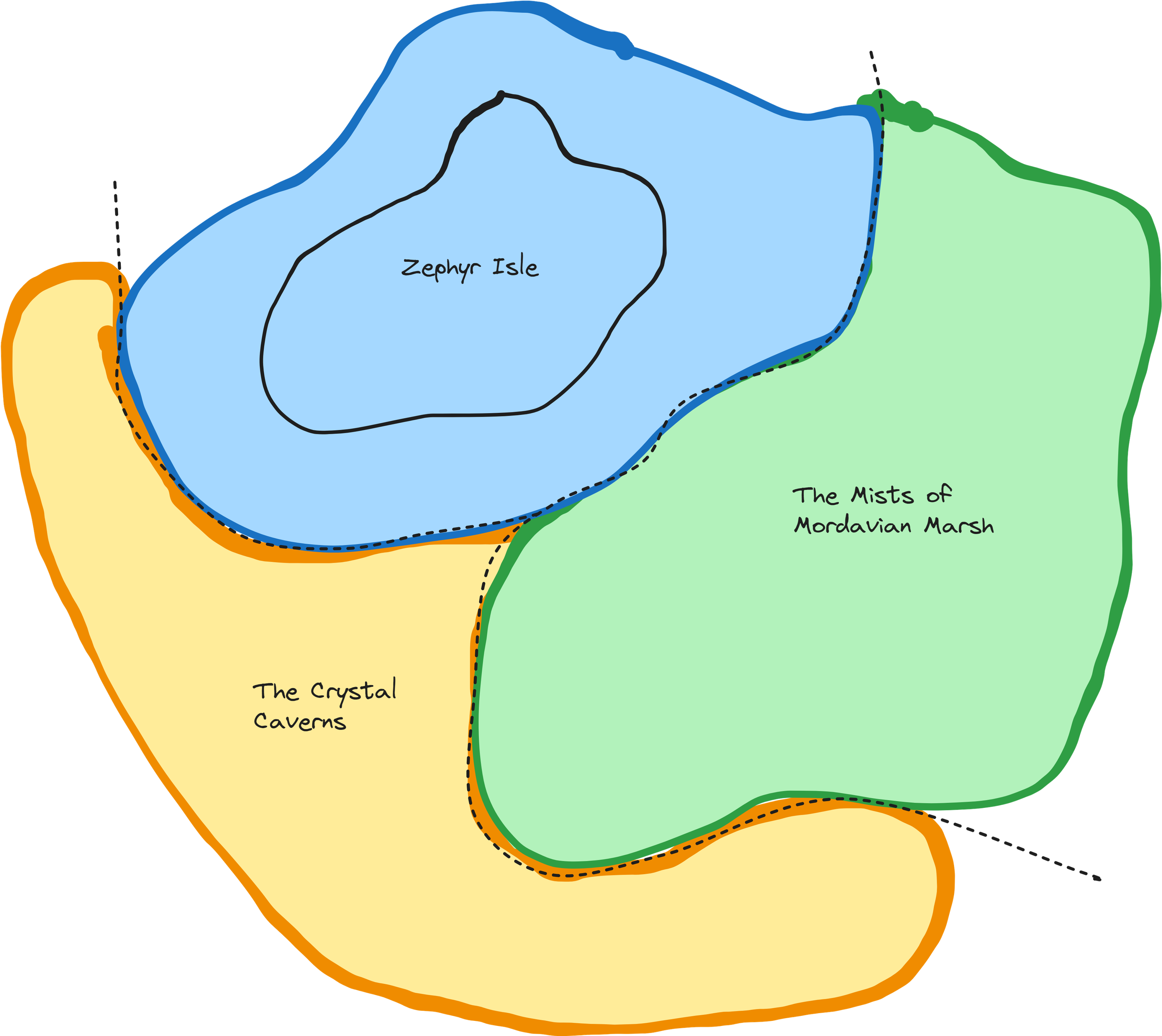 Argenfell Region Outline
Factions
Time for factions! I prefer to have five in total but their presence doesn’t need to be equal. A ruling faction may be present everywhere, some factions may even be a remote hermitage with wild designs in the region. No matter the size, though - they have a vision for the region. They want change.
For each faction, we’ll write their name, description, presence and goal.
Ashul Syndicate. A powerful consortium of miners, gem-cutters, and merchants who control the extraction and trade of the precious teardrop jewels found within the Crystal Caverns. Presence: Command vast wealth and political resources. They are known for their ruthless business practices and willingness to eliminate rivals by any means necessary. Goal: To stripmine and exploit the magical teardrop jewels for profit and influence.
Luminary Church. A religious order of scholars, sages, and historians dedicated to unravelling the mysteries of Argenfell and preserving its rich cultural heritage. Presence: Operate research facilities across the region. They are revered as guardians of knowledge and sought out by adventurers for their expertise in all matters relating to Argenfell. Goal: To uncover the tragic history of Marovia and establish a great library in the region. Also, to protect the Great Chime.
Mistwalkers. A small covenant of magic-users who have mastered the art of navigating the Mists of Mordavian Marsh. Presence: Dwell in restored Mordavian watchtowers. Their mist magic makes them logical guides, but they only use their powers for their own ends. Goal: Unlock the secrets hidden within the fog-shrouded marshlands.
Those-who-live-on. A clandestine society of outcasts, rogues, and aimless undead who dwell in the shadowy depths of the Mordavian Marsh, beyond the reach of civilised law. Presence: Operate from concealed lairs within the marshlands, where they can be employed for clandestine activities such as smuggling, espionage, and assassination. Goal: To establish a haven for those who are not accepted by society.
The Elves. A small community of masked elves (the Zephyri) that commune with spirits of wind and water. They are deeply mistrustful of outsiders. Presence: Their speedy sand-ships cut across the isle to assail any intruders who bypass their summoned storms and sea monsters. Goal: Use the land-rituals of Zephyr Isle to create an impenetrable barrier and prevent interference from the syndicate and church.
From there you can build out relationship diagrams and flesh out the NPCs/POIs related to them - but let’s not get distract too much. On to…
Ecosystems
Play occurs in the space between rules, and to create interactivity and depth into the natural world, we need to insert some laws of nature. There are a few ways we can bring the natural world to life.
Laws of the Land
I’ve shamelessly borrowed the concept of ‘Laws of the Land’ from this excellent post, so I highly encourage you to read more there.
Each ‘Law’ should be specific and have three parts — a statement starting with Always or Never, which action you take, and the consequence of ignoring this law. There should also be a situation where it is important (eg. when swimming, at sunrise, during rainfall) or tie it to a specific Area:
- Mistwalker’s Creed (Mists of Mordavian Marsh): Never bring animals or livestock, for they will disturb the spirits that dwell within.
- Crystal Cave Etiquette (Crystal Caverns): Never carry light brighter than a dwindling candle, as the delicate teardrop jewels will melt away in the presence of heat and brightness.
- Zephyr’s Dissonance (Zephyr Isle): Always move slowly and softly to avoid disturbing the harmonious melodies that resonate through the island; otherwise you risk an unwelcome curse.
I recommend one per Area, but you could have several region-wide ones instead.
Ecological behaviour
Encounter behaviour allows us to simulate a simple food chain:
monsters → people → predators → prey (→ flora*)
This order has exceptions and complications, but roughly it follows these descriptors.
Apex Predators: Super-predators that have no predators of their own within their habitat, except ambitious adventurers (dragon, kraken, aboleth). Typically 6+ HD.
People: Humanoids that seek out fauna and/or flora. Typically 1-4 HD.
Predators: Carnivorous beings that hunt prey and attack people (owlbear, wolf, stirge). They likely have predators of their own.. Typically 3-5 HD.
Prey: Herbivorous beings that predators hunt and kill (deer, goat, unicorn). Typically 1-2 HD.
Flora: Trees, shrubs, grasses, flowers, and fungi. They grant limited effects when prepared correctly. Rather than sitting on an Area’s random encounter table, they grow in specific circumstances (see ‘Unique flora (and other resources)’ below).
The boundaries are blurred here… dragons employ more intelligence than some humanoids, such as ogres. Some plants like the assassin vine can be considered a predator. However, looking at this spectrum can help you build gameable details into your regional bestiary.
For each creature, you can consider how it avoids or protects against those higher-up the food chain… and why it hunts those below it on the food chain.
I hope to revisit this in another post - but for now, consider having doubles/triples on your 3d6 encounter roll triggering a new paired encounter that resolves simulataneously and follow the logic below:
| Flora | Prey | Predators | People | Monsters | |
|---|---|---|---|---|---|
| Prey | - | Competing if same, if not abundant | Predators → Prey | People → prey | Monsters → prey |
| Predators | - | - | Competing if different, if not abundant | People → predators | Monster → predators |
| People | - | - | - | Collaborating People | Monster → people |
| Apex Predators | - | - | - | - | Competing Monsters |
Unique flora (and other resources)
A side-point regarding flora. A dungeon is a location for a handful of sessions (barring megadungeon play), but a region is the focal-point of a sandbox campaign. For this reason, creating a consistency amongst the resources across the whole region rewards long-term play significantly. I am a huge fan of DG Chapman’s Modular Ecology post, and I wanted to share how I use it.
First, identify 6 key resources (typically flora, but it could be some other natural or magical phenomena). Next identify how each is found or gathered (again, check DG Chapman’s post for great examples). And finally detail two uses for them (make sure these are gameable / “toyetic”).
Then for each of those facts (Source, Use A, Use B) assign whether it’s landmark (everyone knows this), hidden (encountered during play), or secret (encountered by challenging investigation).
Example:
Salt-rice. In a coastal village devastated by a storm, the sea god Hulanti granted the people a crop that thrived in salty waters, to ensure their survival during the Sea Season.
- Source (Landmark): Other than on coastal farms, it is found natively as a coastal weed, where sand meets grass.
- Use A (Hidden): Used to enrich food, allowing uncooked rations to be treated as preserved rations.
- Use B (Secret): Used as a charm against temperamental weather. A bundle kept around your neck keeps rain off you (though it can still make your pack wet).
Weather and seasons
Weather and seasons help us give unpredictable timing to our exploration. Traditionally, this comes in the form of bad storms that hinder traversal or transport. That’s already taken care of, so I’m going to flip it on it’s head. Weather and seasons can grant unique opportunities for savvy adventurers.
Consider each Area above, let’s highlight an ecological phenomena that call players to adventure at each:
Solar Eclipse (The Mists): Once in a great while, a solar eclipse occurs, causing the already gloomy marsh to plunge into darkness. During the eclipse, the boundary between the living world and the land of the dead weakens, allowing spirits to materialize more easily. Additionally, the sudden darkness can disorient creatures and alter their behavior, leading to unexpected encounters and challenges. Fancy walking the halls of sunken Mordavia?
Bioluminescent Bloom (Crystal Caverns): Following a heavy rainstorm, a rare and magical phenomenon known as a bioluminescent bloom occurs within the caverns. Fungi and mosses trailing the cave walls emit a soft, otherworldly glow, illuminating the tunnels with a faint blue light. This illumination doesn’t harm the teardrop gems and the mining operations and adventurer delves increase in zeal.
The Windchord (Zephyr Isle): Every winter, a gusty storm rises harmonising with the eerie hum of the desert sand, creating a new symphony. During this season, the Zephyri elves cannot launch their land-ships. However, the storm uncovers hidden mechanisms beneath the sand, as long-buried ruins and artifacts to emerge from the earth. Adventurers navigate the shifting sands and tempestuous winds to explore the unveiled arcology site before it’s buried again.
This is also a great way of adding new POIs to an existing area. Building on your region during the campaign is an important opportunity to have it evolve and grow. Consider also how does weather and seasons and other environmental phenomena change the context of an area and the POIs within.
What’s to come…
Sorry about the long wait on this. It’s only my 5th post and I’m still trying to find my groove (it’s been in my drafts for months). I hope you find it helpful and it prompts your own interesting ideas.
Next up, we will explore Micro Meso and Macro Landmark and their role as navigational aids in the overworld.
Further reading
https://monstermanualsewnfrompants.blogspot.com/2019/04/keystone-species-encounter-table.html
https://wasitlikely.blogspot.com/2023/03/laws-of-land-meaningful-terrain-via-in.html
https://graverobbersguide.blogspot.com/2023/05/modular-ecology.html
https://hexculture.com/2024/01/food-web.html
I’ve seen some sneak-peeks of Cairn 2e’s sandbox and wilderness creation procedures. If you like this blog series, you should check out the highly anticipated boxed set.